Walter W Snailum
Architect
Trowbridge
Walter W Snailum signed George Edward Hubbard's RIBA declaration on 14/12/1922.
Can I find any evidence of father's work??? On a drawing? Some reference? Some graffiti?
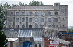
I remember being driven through Trowbridge and father pointing out a warehouse, and saying the word "architect" - but I was too young to comprehend these words - 1968.
Clipping
"On his [George Edward Hubbard's] return to England he joined the staff of the County Architect at the Shire Hall, Gloucester, after which he was for five years chief assistant to a firm of architects in Trowbridge, Wilts."
Walter W Snailum signed George Edward Hubbard's RIBA declaration on 14/12/1922.
Kelly's Directory of Wiltshire 1915
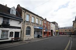
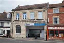
Kelly's lists Walter Wadman Snailum office at 5 Church Street, Trowbridge.
Snailum's son, Terrence Walter (1904-1995) was also an architect - so "Messrs Snailum and Son" on a post card in January 1930. (Link to an Ebay sale of a wretched postcard would be an abject waste of time!)
5 Church Street, Trowbridge today...Google street view
What did Walter and his chief assistant get up to?
I don't know!
But let's list some candidate buildings...
Trowbridge Civic Society NEWSLETTER Autumn 2011
NEWTOWN CONSERVATION TRAIL
"In 1991 Michael Lansdown wrote the Newtown Conservation Trail for the newly-formed Newtown Area Residents' Association. It is a guide to the streets and buildings of the area. This has long been out of print and it is hoped that it might be re-printed in the future. The following is a much-shortened version (PC).
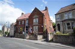
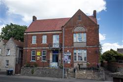
"This area of Trowbridge was built from about 1800 to 1900, but most houses were erected from 1860 onwards. It was a compact neighbourhood with a wide mix of social and economic classes. With generous back gardens to mainly terraced houses, the overall density is about 15 to the acre. The visitor will be pulled up now and then by jarring notes: inappropriate additions, replacement windows and doors and ‘cladding’, but the area as a whole has a character truly worthy of conservation. The area is named from the street now called Newtown, but it was earlier named, Pilewell'. About 1790 a three storey terrace for mill workers was built on the west side of what is now Newtown. The great open West Field, which lay to the west of this lane was originally cultivated in strips by the townsfolk. The strips ran roughly north-south and when the field was enclosed in the 18th and 19th centuries the new fields were bounded by hedges following the direction of the strips. As one field after another was developed with suburban housing the layout of the streets followed the lines of the hedges. The Newtown area echoes in its layout the strip fields of medieval times. The houses on the east side of Newtown were not developed until 1892, a hundred years after the first houses opposite them. This was because the Bythesea family, who owned land from Newtown down to the river, held it back from development until this time. The former Co-op shop was built in 1906 by the Trowbridge Co-operative Society. There is a very fine wheatsheaf emblem carved in stone over the door by Palmer and Shepard of Bristol. The drawing for it was made by Walter W Snailum, a Trowbridge architect. Opposite is the brick-built Labour Club of 1924 by the same architect. On the other side of Gloucester Road from the old Co-op is Bethesda Baptist church built in 1930, also by Snailum. Several houses along Newtown were pulled down in 1930 and replaced by the advertising hoarding. Beyond this are the original 1790 ish houses. Number 14 was refronted when it was the Rising Sun. Number 26 has its original rubble front. Across the road one can see subtle differences of detail in what look like uniform terraces - shapes of doors, windows and bays and their arrangement; flat lintels or arches; carved foliage ornament. Small builders would buy a few plots, build a few houses and after they had been sold take a few more lots along the road.
"Pilewell Terrace on Newtown is a rank of 16 houses with very long front gardens. They date from 1840. Park Street School, opposite where Park Farm used to be, was built in 1873 by Richard Gane junior, a Trowbridge born architect, who was also responsible for Abbey Mill, Bradford on Avon. The plain brick and stone terraces in Park Street, Bond Street and along the Frome Road date from 1865. The West End Building Society owned 6 acres of land in 54 plots. It would lend builders £15 toward a £20 plot and three quarters of the £146 cost of building a house. Such houses continue beyond Waterworks Road with the Anchor and Hope Inn in the centre. This was opposite the main gates of the Artillery Barracks and Mass was celebrated in the rear upper room of the inn for Irish and other Roman Catholic soldiers until the Catholic church was built in Wingfield Road. Waterworks Road is named after the first Trowbridge Water Company, formed 1864, which failed to get drinkable water from its deep well and pumphouse (site of Henderson Close). Bricks for the works and houses came from clay in a nearby field. In the 1870s a Bristol builder, Durke, built 54 houses ‘on the site of the waterworks’. In Gladstone Road, which is off Waterworks Road, four of the more distinctive houses (1883) are by Edward Linzey, founder of the town's leading firm of builders up to the 1960s. The others are by the builders W R Moody and T W Lyles. Between Waterworks Road and Bond Street there are three distinctive terraces running at right angles, their fronts facing long gardens and their backs facing narrow access lanes. Park Street was built mainly in the 1880s. The northern end was at one time called New Park Street. On the corner of Westbourne Road and Gloucester Road was a post office and shop - Luxfords (now converted into flats). This was built about 1890 and opened in 1892 by T H Watson. On the opposite corner is the Conservative Club established in about 1907. Close to the John of Gaunt School is the Rural Music School which seems to be by Durke with a very odd cornice like gear wheels. For many years it was the home of Henry J Knee, founder of Knees department store. The former Girls' High School dates from 1932. Gloucester Road, still called Studley Lane in the 1871 census, was meant to link with Pitman Avenue. In fact on the 1899 map Pitman Avenue was called Gloucester Road. There is still only a footpath here.
"Avenue Road was ‘highest in the social hierarchy of three streets opening off Wingfield Road: West Street, Westbourne Road, Avenue, known early in this century by the irreverent nicknames of Threepenny, Sixpenny and Shilling Streets!’ The field on which the houses were built was called Tyning and was sold for building plots in 1889. The site was described as ‘the most eligible site in the town...will beeagerly sought after as houses and villa residences are in great demand’. The first houses built were ‘a pair of grand villas with four bedrooms, bathrooms, separate WCs, three reception rooms, etc.’ The builders responsible for many of the houses were Lyles (in 1911 a builder called Lyles lived for some time at number 38, presumably the same) and E Linzey. ‘Linzey had a distinctive way of turning the corners of his window bays, with two stone quoins showing alternate wide and narrow faces. His houses get grander towards the bottom, with stained glass, etc. Nos. 25 and 27, higher up, stand out with deep keystones carved with low relief foliage’. The detached houses opposite John of Gaunt School in Wingfield Road and the groups and single houses as far back as No 20 were built by Linzeys from 1890 to 1907. Some were designed by Snailum who lived at No 46. The road which now leads down to St Augustine's School was meant to link with Bradford Road as a housing development called Mornington Gardens, which came to nothing. Between Westbourne Road and West Street there is a ‘pretty little’ Victorian Terrace, dating back to the 1850s with royal heads over the doors and, at the corner of West Street, prettily patterned bricks. In 1871 Trowbridge Co-operative Society bought a field on which now stands Westbourne Road.
The earliest houses seem to be those with round-arched doors and windows and much foliage carving, by a builder named George Fluke. He, apparently, carved all the pretty leaf capitals in this and many other Trowbridge streets. The larger pairs, with battlemented bays and veranda-like porches were built from 1895 to 1898 by Lyles who lived in one. Many others also were built by Lyles. Back in Gloucester Road some of the houses have ‘strangely classical pediments’ and, almost opposite the end of West Street is an archway with a sculptured keystone of a craftsman's head with decorator's tools. In the 1870s this was where Lyles had his yard. Later a blacksmith had it. West Street was developed from the late 1860s onwards. Facing West Street in Wingfield Road are Alexandra Villas with their odd turrets.
"Next door is St John's Church, 1876 by A J Scholes and what was once its school (1935). On the opposite side is Elm Villa, with a classical doorway, two houses by Snailum (1903) and Westview Terrace (early 1870s). Finally there is the recently restored Stallards Inn (Newsletter Spring 2009) on the corner of Newtown and Wingfield Road, built about 1860. A good place to rest after this tour."
British History OnLine
Three extracts...
Since the late 18th century Trowbridge has been a home of brewing. Edward Sheppard, brewer, occurs in 1782. (fn. 537) Messrs. Watten & Timbrell owned several public houses in the town in 1814. (fn. 538) Messrs. Usher & Co., Ltd., Manvers Street, is said to have been founded in 1824 (fn. 539) and is now a substantial concern. The family is perhaps an old one, for a John Usher, of Trowbridge, was living in the late 17th century. (fn. 540) In 1842 Thomas Usher lived in Back Street. (fn. 541) The present brewery buildings were designed by W. W.Snailum (d. 1934). (fn. 542) [Wilts. Times, 26 Aug. 1922.] In 1842 there were three other breweries: Curme & Joyce, wine and spirit merchants, of Back Street; Edward Mandry, Market Place; and William Nightingale, Silver Street. (fn. 543) The firm of J. H. & H. Blake, Union Street, existing in 1903 but now departed, was of 19th-century foundation. (fn. 544)
In 1665 a pest house is said to have been established as a quarantine station. It stood at the south corner of 'Choksalls', near the Biss. The house had gone by 1814. (fn. 928) In 1870 a cottage hospital was established at Fernleigh House in Church Street, (fn. 929) evidently in connexion with the Tabernacle Church. (fn. 930) The foundationstone of a new cottage hospital with eight beds was laid in the Halve in 1883. (fn. 931) The costs of erection were met by Jesse Gouldsmith, partly by gifts during his lifetime and partly by bequests. The nuclear site was conveyed in trust in 1885 and additional land in 1892, 1894, and 1896. The first two gifts were made by Hannah Gouldsmith, Jesse's relict, who also gave some houses in the Halve towards an endowment under a trust created in 1902. In the same year other houses there were conveyed in trust by Sir Roger Brown, who also by his will, proved in 1902, bequeathed £1,000. In 1902 the hospital was still managed by a committee of five as provided by the trust deeds of 1886. There were then seven honorary medical officers, an honorary dental officer, a matron, and a nurse. (fn. 932) In 1927 Adcroft House, formerly the home of Burchell Rodway, was purchased as the site and nucleus of a new hospital. Building was begun in 1928, and the hospital opened in 1929. Messrs. A. J. Taylor and A. C. Fare, of Bath, and W. W.Snailum, of Trowbridge, were the architects. (fn. 933) [Wilts. Times, 14 Sept. 1929.]The old cottage hospital building was bought by the County Council in 1929 as a new site for the Trowbridge school clinic, which, since at least 1923, had been situated in Bythesea Road. (fn. 934)
Bethesda Chapel, a Baptist congregation, was founded in 1821 by a body of worshippers who migrated from the Back Street chapel. The separatists met first in Back Street Sunday School and later in a warehouse on Wicker Hill formerly used by the Zion Chapel congregation. In 1822 a site for a new chapel was purchased from the trustees of William Dunn in the Courts (now Court Street). Here a chapel was erected at a total cost of £2,100 and opened in 1823. The site was conveyed in trust in 1825. (fn. 1227) In 1829 the congregation was said to number 400. (fn. 1228) In 1840 a Sunday schoolroom was built and opened. In 1856 a piece of land behind the chapel adjoining Home Mills was sold to Jesse Gouldsmith for £100. (fn. 1229) In the same year the graveyard was closed. (fn. 1230) In 1862 the chapel was slightly damaged by the fire that then nearly consumed Messrs. Salter's factory. In 1868 the galleries in the chapel were grained and the pews stained. During the pastorate of Amos English (1867–89) considerable alterations were done. The very high old pulpit was replaced by a platform above the baptistry and the schoolrooms and vestry enlarged. (fn. 1231) In 1885 four cottages in Court Street were conveyed in trust, the rents to be applied to church purposes. These and the rest of the trust were regulated by a scheme of the Charity Commissioners of 1898. (fn. 1232) In 1890 a new organ was built and the chapel renovated. It then contained two galleries, one above the other, running round three sides. Doorways led from the schoolroom to the first galleries. There were 840 sittings. (fn. 1233) In 1930 the foundation-stone of a new chapel was laid in Gloucester Road and a building designed by W. W.Snailum, of Trowbridge, erected. (fn. 1234) The old chapel building was sold by order of the Charity Commissioners in 1930. (fn. 1235) It is now (1950) occupied by Messrs. Samuel Salter & Co. (fn. 1236) In 1931 the congregation moved to the new chapel, (fn. 1237) which furnishes 350 sittings. (fn. 1238) In 1890 the membership was 230, with 50 superintendents and teachers, and 450 school-children, all of whom enjoyed the benefit of a lending library. (fn. 1239) The present membership is 95 with a Sunday school of 81 pupils and 16 teachers. There are a settled pastor and 3 lay preachers. (fn. 1240)
Trowbridge
Nick Visits June 2022
Warehouse on County Way
W Ashton Rd, Trowbridge BA14 7BA
Snailum's former offices 5 Church Street, Trowbridge
Snailum's former offices 5 Church Street, Trowbridge
Newtown Social Club, Trowbridge
Newtown Social Club, Trowbridge
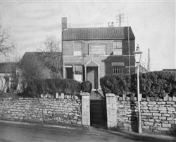
Trowbridge Trades and Labour Club and Institute
Photo of the original building that was burnt down,
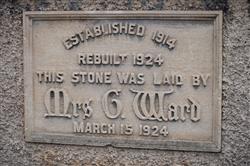
Rebuilt in 1924.
Photo frame in the club
Newtown Social Club - Foundation Stone
Ward 1924
